Where does the sun fall on your lot?

  1. Type your address anywhere in Metro Vancouver.
  2. See your lot in 3D, with its real neighbours, trees and buildings, built from laser scans of the city.
  3. Find the sunny and shady spots: sun and shade right now or at any time, and hours of direct sun over a day or the growing season.

Try an example:

Covers the 21 municipalities, Electoral Area A and Tsawwassen First Nation in Metro Vancouver. Free, with no account. Addresses are looked up with BC's public address service; VanShade keeps nothing.
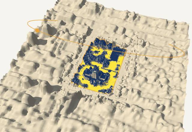
Example result: Vancouver City Hall's lot in 3D among its neighbours, with sunny lawns in yellow and shaded areas in dark blue
Vancouver City Hall: yellow gets full sun, dark blue is shaded.

About VanShade and its accuracy

VanShade works out where direct sunlight falls on a Metro Vancouver lot. It finds the lot from your address, loads 1 m LiDAR elevation for the lot and 200 m around it (roofs, neighbouring buildings, trees and hedges included), and for every square metre of the lot works out which parts of the sky are blocked. It then looks for sharper and newer LiDAR: by default it keeps the 0.5 m detail of NRCan's point clouds wherever the Province's 2024–2025 surveys show nothing changed, and uses the newer survey wherever something did. "3D data" under More options lets you pick either survey on its own. It then follows the sun across the day or season to count hours of direct sun. Everything runs in your browser; nothing is sent anywhere except the map data requests and, for Analysis, a short written summary of the lot's results and any questions you ask, which go to Google's Gemini to write the answers.

How to use VanShade

  1. Type your address and pick it from the list. If the outline isn't your lot, choose another under "Not the right lot?".
  2. Read the result: the sentence at the top of the panel sums it up, and on the lot yellow spots get the most direct sun, dark blue the least.
  3. Choose what to show (Advanced mode): one moment (it opens on now), one day, a season average (best for planning a garden), or the shade finder (how often a patio is shaded at a time of day). Click any spot for its sun month by month.

Words used here

Direct sun
Sunlight reaching a spot with nothing in the way. Bright shade and light reflected off walls don't count.
Roof or tree overhead
Something more than 2 m tall stands over the spot. At garden-bed height these spots are mostly in shade, so the summary leaves them out.
Garden bed, seated, rooftop
Where the sun is measured: 0.3 m above the ground, 1.2 m (about head height sitting down), or just above whatever surface is there, such as a roof or deck.
Laser scans (LiDAR)
Measurements of the ground, buildings and trees taken from an aircraft. VanShade uses scans from 2016 and, where they exist, 2024–2025.
Full sun, part sun, shade
How the lot is coloured for a whole day or season: full sun is 6 or more hours of direct sun a day, part sun 3 to 6 hours, shade under 3. You can change these numbers, or untick the option to see exact hours.
Season average
The average number of hours of direct sun a day over the months you choose.
Typical weather
The hours of direct sun you'd expect with an average year's cloud, month by month. They come from the sunshine recorded at Vancouver or Abbotsford airport, adjusted for local cloud with a weather model. The main numbers stay "on clear days", the way plant labels count full sun.

What to keep in mind

Data and credits

Welcome to VanShade

VanShade shows where the sun falls on any property in Metro Vancouver, square metre by square metre, from laser scans of the city. It can help you find the best spots to plant vegetables, a shady place for the patio, or how much sun a home gets before you buy it.

To start, what are you most interested in?

About these numbers